Stories in History
The World: Continents & Oceans Coloring Map, Kindergarten–1st Grade Geography
The World: Continents & Oceans Coloring Map, Kindergarten–1st Grade Geography
Couldn't load pickup availability
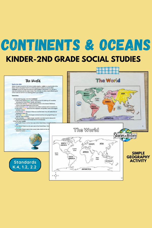
Introduce young learners to the world in a fun, hands-on way with this continents and oceans coloring map activity! Designed for Kindergarten–2nd grade, this low-prep geography project helps students begin understanding how our planet is organized.
In this activity, students color and label the 7 continents and identify the major oceans using a simple, black-and-white world map. A short, kid-friendly script is included for adults to read aloud, introducing key vocabulary like globe, continents, and oceans in an age-appropriate way. Each continent includes a simple, engaging fact to help students build early geographic awareness.
This activity is perfect for:
- Homeschool families
- Classroom centers
- Geography introductions
- Sub plans or early finisher work
✔️ No prep
✔️ Print-and-go
✔️ Kid-friendly and engaging
✅ What’s Included
- Read-aloud introduction for parents or teachers
- Black-and-white world map with labeled continents
- Coloring instructions for all 7 continents
- Identification of the Pacific, Atlantic, and Indian Oceans
- Simple continent facts for young learners
📚 Social Studies Standards Addressed (Kinder–2nd Grade)
California History–Social Science Standards
-
K.4 – Students understand basic geographic features and models (maps and globes).
-
1.2 – Students locate places and identify geographic features using maps and globes.
-
2.2 – Students demonstrate map skills and basic geographic knowledge.
C3 Framework (National Social Studies Standards)
-
D2.Geo.1.K–2 – Use maps and globes to identify locations of places.
- D2.Geo.2.K–2 – Identify physical and human characteristics of places.
*This is an individual worksheet from Stories in History's 1st and 2nd-grade full-year social studies curriculum called My World, My Story.
Share